OUR today’s EUROPEan traditions are the pasts’ migrating cultures”
OUR EUROPE


Municipality of Rakovica - Općina Rakovica
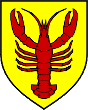
River Korana, karst phenomena, rich flora and fauna and convenient location are just a few of the indicators that the municipality of Rakovica is attractive to many visitors. District Municipality has been inhabited since the earliest times as it is proved by numerous archaeological findings in caves. Name of the settlement according to which the municipality got its name is mentioned in historical documents from the beginning of twentieth century. At its root name, Rakovica has adjective rakov (crab`s) given by the name of the creek inhabited by crabs.
The municipality is located in the south of the Karlovac County, more precisely between the town of Slunj and Plitvice Lakes National Park. It partly borders with Bosnia and Herzegovina, and the state road D1 Zagreb – Split passes through that area. The total area of the municipality is 261 square kilometers, and in its composition there are 26 settlements in which lived 2401 residents in year 2011.
Old Town Drežnik on the edge of the Korana River canyon is mentioned in the 11th century. In the times of Turkish conquests, it was an important fortress, defeated, demolished and reconstructed on several occasions. The exisiting fortress ruins have been declared a cultural monument. Three Caves of Barać are located near the village Nova Kršlja: Upper (big), Down (little) and New. Caves were important habitat for humans in pre historic and middle age era.
Plitvice Lakes National Park is declared as a UNESCO World Heritage site from 1979.
Municipality Rakovica: http://www.rakovica.hr/
Tourist Board of Rakovica: http://rakovica-touristinfo.hr/
Caves of Barać: http://www.baraceve-spilje.hr/
Plitvice Lakes National Park: http://www.np-plitvicka-jezera.hr/
Description of Plitvice Lakes National Park – UNESCO World Heritage site: http://whc.unesco.org/en/list/98